 rivers | guidebooks | forums | tips | other
Class: IV+; Ave. Gradient: 11 m/km; Portages: wood?; Length: 16 km + Lower; Time: 4 to 9 hrs + Lower
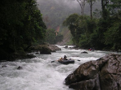
Season: June to February; rafts? yes; Highlights: multi-day trip with stunning canyon and clear water; Crux move: planning and negotiation
Water Quality: good; Water Temperature: cool-cold
PI: Limonar (elev: 435m), or above on the Río Putul; TO: lower Río Chixoy
Description: (click here for general notes about my descriptions)
*Warning: the last group to try the Copón in January 2012 was detained by the local communities. Don't chance it.*
The Copón competes with the Jataté in Chiapas for the title of the best multi-day whitewater trip in Mayan WhiteWater-land, perhaps in all of Central America, and in many aspects surpasses it. The canyons are spectacular, the jungle is pristine, and the rapids are world-class. The only problem (shared by the Jataté but again surpassing it) is getting access to it, as the river is in one of the most remote places in Guatemala, a region called La Zona Reyna, and some of the communities are very suspicious of outsiders playing around in their backyard.
A full description is in the Mayan Whitewater Guatemala guidebook.
Flash Flood Danger: high. Avoid extreme weather.
Descent History: The first descent was a rafting expedition with one paddle raft and two oar rafts, camping four nights on the river, executed in January 2006 by trip planner Roberto Rodas, guides Bruce Keller and Jim Slade, and other members Barbara Slade, Jeff Shryer, Alejandro Aguilar, Ken Smith, Joani Carpenter, Jimmy Hanson, Jimmy Hanson III, and Jon Hanson. I was safety kayaker. The trip is described by Bruce in the book First Descents: In Search of Wild Rivers (see my bibliography) and the Mayan Whitewater Guatemala guidebook. I have been down the Copón twice since, the latest in February 2008.
Flow Notes: The only useful online gauge, shown below, is far downstream on the larger Río Chixoy, but may give a hint about relative levels. This river has water year-round. I have seen early-"dry season" flows range from 600 cfs to 2500 cfs, and it could be navigated at much higher flows. I guess that March to May may get a bit low for rafts in low water years. Normal rainy season flows are unknown, but I would expect at least twice the flow.
 |
Nearby Tourist Attractions: Getting to and experiencing this remote part of the country is an experience in itself.