 rivers | guidebooks | forums | tips | other
Class: III; Ave. Gradient: < 1 m/km; Portages: none; Length: up to 63 km, or more; Time: 1 hour to several days
Season: year-round; rafts? yes; Highlights: scenery; Crux Move: Cañón Colorado
Water Quality: good; Water Temperature: warm
PI: Amatitlán/La Democracia (elev.: 185m); TO: Chajul
Description: (click here for general notes about my descriptions)
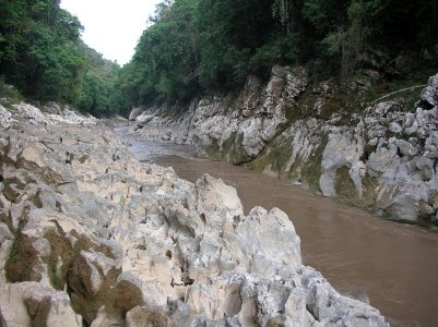
The Lacantún connects the Ríos Jataté and Santo Domingo (and further downstream, the Lacanjá) to the Río Usumacinta. It is off the beaten path, and being flat except for the narrows at Cañón Colorado, is of little interest to most paddlers. But for the endurance masochistics out there who have in mind to link up a long trip, or for those of you who otherwise are exploring the area and want to get in some extra float time not afforded by the Santo Domingo and its crazy canyons, this page is for you.
A full description is in the Mayan Whitewater: Chiapas & Belize guidebook.
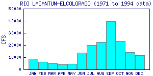
Flow Notes: There is a handy gauge at Estación Chajul (linked to below), below the confluences of the Ixcán and Xacbal. I have not verified its accuracy. There is always enough water to float here, though there are some shallow spots in the dry season. I would suspect that the Cañón Colorado can get more than a bit squirrelly at high water. Here I also show historical data from INEGI also:

click here for the height graph |
 |
Accommodations: Hotels are few and far between in this area. There are informal hospedajes in La Democracia.
Nearby Tourist Attractions: Estación Chajul Biological Research Station.