 rivers | guidebooks | forums | tips | other
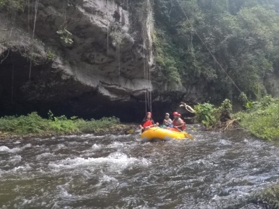
(photo courtesy of La Moskitia Ecoaventuras)
Class: III+ ; Flow: 200-1,500 cfs; Average Gradient: 3 m/km; Portages: fallen trees and the Subterráneo; Length: 113 km; Time: 1 week+
Season: year-round but best July to February; rafts? yes; Highlights: remote wilderness expedition; Crux move: jungle trekking (map on page 187)
Put-In: Guarascá (405 m); Take-Out: Las Marias (23 m)
Description: (click here for general notes about my descriptions)
(The following description notes are courtesy of Udo Witteman of Omega Tours.) The Río Plátano passes through the Río Plátano Biosphere Reserve, part of the biggest and most remote jungle area in the Americas apart from the Amazon basin. Since the Biosphere is protected from almost all human activity, it is a trip where you experience wilderness at its best and a clean river from its source to the Caribbean Sea. A trip down the Río Plátano is a real expedition with 4x4s, mules, rafts, hiking, fishing, petroglyphs, artifacts, different indigenous cultures, campfires, animal encounters including poisonous snakes such as the Fer de Lance--you name it!
A full description is in the Mayan Whitewater El Salvador, Honduras, & Nicaragua guidebook.
Descent History: The local Pech Indians are expert boatmen and fishermen and have run up and down this river in canoas for generations. The first modern expedition was organized by the NGO MOPAWI and led by a Miskitu Indian named Allen Rivens in 1988. The group documented many of the new human threats to the supposedly protected area. Unfortunately, one member of the team fell into the river above the subterráneo and was never found. Jorge Salaverri relates more river background in his article on page 196.