 rivers | guidebooks | forums | tips | other
.jpg)
Class: II; Ave. Gradient: 4 m/km; Portages: wood?; Length: 11 km; Time: 2 hours
Season: June to October; rafts? no; Highlights: beginner run; Crux move: getting all the way out here
Water Quality: poor; Water Temperature: medium
PI: Cubulco road (940 m); TO: Xococ (900 m)
Description: (click here for general notes about my descriptions)
The Río Xolacoy is a pleasant float through the caña grass and hills of the area. It has a remote feel and you are likely to have the place to yourselves along with a few cows. You are also likely to encounter wood in a few places that will partially or fully block the river requiring a quick portage.
A full description is in the Mayan Whitewater Guatemala guidebook.
Descent History: First floated September 2013, by me and Nils Saubès, with 150 cfs.
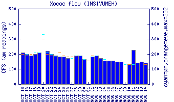
Flow Notes: The Río Xolacoy is hard to catch. The gauge downstream on the Río Xococ should help a lot. But if the Río Salamá in downtown Salamá doesn’t have at least 300 cfs in it, don’t bother driving further.
 |
Nearby Tourist Attractions: not much in this area.