 rivers | guidebooks | forums | tips | other
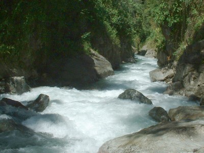
Class: V; Ave. Gradient: 20 m/km; Portages: many; Length: 5.5 km; Time: 6 hours
Season: June to February; rafts? no; Highlights: challenging creeking in a narrow canyon; Crux move: careful scouting, including the political situation
Water Quality: good; Water Temperature: cold
PI: Xacbal Delta dam (950 m); TO: Juá bridge (842 m)
Description: (click here for general notes about my descriptions)
The Middle section of the Río Xacbal (sometimes spelled Xaclbal or Xalbal, or sometimes called Río Chajul) takes the rapids of the Upper section up a notch. The canyon is deep and narrow, and you pass through many bedrock gorges. The action is fun, continuous, creeky, demanding, and beautiful. Expect to portage a lot, and expect a lot of wood. At lower levels, I figured everything was hair-boatable. The drops generally increase in size through the run. The X-factor here is that the run is now dried by the Xacbal Delta hydroelectric dam, so runs only when the dam is spilling.
A full description is in the Mayan Whitewater Guatemala guidebook.
*This run is marked politically sensitive because of conflicts over the Xacbal dams. Hopefully, taking out at the Juá bridge should not cause any issue, but expect to be questioned by the locals about your strange activities. In 2015 there were violent conflicts with local communities because of the project. Endeavor to find out the political climate in the area before driving in. Access is likely a bigger issue, you will need to enter dam property to put-on.
Descent History: I ran this solo in February 2004, with 400 cfs at the PI (pre-dams).
Flow Notes: Xacbal Delta dam spilling flows are not available online (but inflows being higher than outflows on the gauges would be a hint about it). I believe the scouting, not to mention the paddling, would be extra tough at flows over 1,000 cfs, more likely in the high water months of August and September.
 |
 |
Nearby Tourist Attractions: The Ixil triangle: trekking and culture near Nebaj, San Juan Cotzal, and Chajul.
mayanwhitewater.com, the guide to the rivers of Chiapas, Guatemala, Belize, Honduras, El Salvador, and Nicaragua © 2008-2024
![]()