 rivers | guidebooks | forums | tips | other
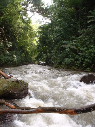
Class: IV; Ave. Gradient:28 m/km in Upper, 12 m/km in Lower; Portages: yes; Length: up to 20.5 km; Time: up to 6:30
Season: June to October; rafts? no; Highlights: jungle atmosphere; Crux move: finding the river, and portaging the wood
Water Quality: decent; Water Temperature: cool
PI: Finca Buenos Aires (515 m) or CA-2 (220 m); TO: CA-2 or Caballo Blanco (60 m)
Description: (click here for general notes about my descriptions)
The rivers that descend the Retalhuleu volcanic hillsides dig deep, verdant trenches between coffee plantations. I have explored three of these fantastic creeks: Xab, Nil, and Ocosito. The Upper Río Xab, with gorgeous jungle and idyllic side waterfalls, is perhaps the coast’s best run in terms of atmosphere (among tough competition). However, there does tend to be a lot of stuck wood, with clearcutting in some areas contributing to the problem. you will see a little trash along the banks, also. There are two sections, the Upper above the highway, and the Lower below.
A full description is in the Mayan Whitewater Guatemala guidebook.
Descent History: I first ran the Upper Río Xab in September 2005, and the Lower Río Xab in June 2011.
Flow Notes: You need heavy, recent rain for a good level on the Río Xab. The Río Ocosito gauge at Caballo Blanco, which also includes the Río Nil, can give you a decent hint. Otherwise you can check the flow at the highway bridge, km 194.9.
 |
Nearby Tourist Attractions: Takalik Abaj Mayan ruins.
mayanwhitewater.com, the guide to the rivers of Chiapas, Guatemala, Belize, Honduras, El Salvador, and Nicaragua © 2008-2024
![]()