 rivers | guidebooks | forums | tips | other
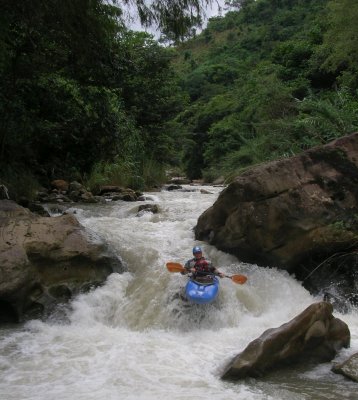
Class: IV, IV, V; Ave. Gradient: 22 m/km; Portages: yes; Length: up to 15 km; Time: up to 7 hours
Season: August to October; rafts? no; Highlights: challenging creeking; Crux move: careful scouting
Water Quality: poor; Water Temperature: not noted
PI: Caserio El Palmar (967 m) or Panamerican Highway (845 m) or El Zapote bridge (765 m); TO: Puente Selegua (635 m) or above
Description: (click here for general notes about my descriptions)
The Río valparaiso offers some excellent advanced and expert creeking near the Mexican border. It suffers from a high population density along the river (mostly hidden though), so you have to be tolerant of trash. Also it is not easy to catch a good flow. I have only run most of it once, and the hardest part not at all, so don’t expect a definitive description here.
A full description is in the Mayan Whitewater Guatemala guidebook.
Descent History: Gary Lee Chrisman and I first ran the Middle in October 2004. I tacked on the Upper and Lower parts in August 2010.
Flow Notes: There is an online gauge downstream in Mexico on the Río San Gregorio. The Valparaiso supplies only a small fraction of that flow however. In 2010, 13,000 on the gauge gave a higher than normal 350 cfs at the Panamerican bridge and 800 cfs at the El Zapote bridge. Less than half of that and you’d be hurting for water.
 |
Nearby Tourist Attractions: not much in this area.
mayanwhitewater.com, the guide to the rivers of Chiapas, Guatemala, Belize, Honduras, El Salvador, and Nicaragua © 2008-2024
![]()