 rivers | guidebooks | forums | tips | other
.jpg)
Class: IV, some III; Ave. Gradient: 11 m/km; Portages: some; Length: up to 34 km; Time: up to 5 hours
Season: June to October; rafts? no; Highlights: roadside creeking; Crux move: the bit below La Florida
Water Quality: poor; Water Temperature: medium
PI: somewhere between Palajachuj (1765 m) and Colotenango (1515 m); TO: anywhere down to Selegua II bridge (1380 m)
Description: (click here for general notes about my descriptions)
The Selegua valley displays traditional village life set in dramatic Himalayan-scale scenery with the luxury of a major road running alongside the river. As a main route from Mexico into Guatemala, it must have intrigued travelers for centuries. The Upper stretch has a nice variety of rapids along the way, though it suff ers from two drawbacks: low water and pollution. The contamination comes from the sewers of Huehuetenango and Chiantla, plus the locals dump trash along the banks. But for me it is still worth doing when there is enough water to cover the rocks and dilute the organic matter. Many cool mountain springs along the way improve the situation on both counts the farther you descend.
A full description is in the Mayan Whitewater Guatemala guidebook.
Descent History: I pieced together the parts of this run between 2008 and 2011, having high water the first half, and low water the second half.
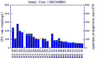
Flow Notes: There is an online gauge on the Upper section, though flows have not been correlated. There is also is an online gauge in Mexico on the Río San Gregorio way downstream (Puente Concordia gauge). You will need the luck of recent rains to have a go here. In 2010, 15,500 cfs on the gauge gave 900 cfs at La Florida, and in 2008, 2,700 cfs on the gauge gave 350 cfs at Selegua II..
 |
 |
Nearby Tourist Attractions: Zaculeu Mayan ruins.