 rivers | guidebooks | forums | tips | other
Class: III+; Ave. Gradient: 6 m/km; Portages: none; Length: 13.5 km; Time: 3 hours
Season: June to October; rafts? yes; Highlights: the Callejones Canyon; Crux move: illegal immigration
Water Quality: poor; Water Temperature: not noted
PI: Finca La Vega Grande (883 m); TO: San José bridge
Description: (click here for general notes about my descriptions)
The run on the Río Olopa, headwaters of the long Río Lempa, over the Honduras border is one of the most spectacular class III runs in Mayan Whitewater-land, passing through the deep and narrow Callejones Canyon. This gorge is almost unbroken for 8 km. The scenery and nature may remind you of the Southwestern USA. There is no one to check your passport at the border, but you can deal with that later.
A full description is in the Mayan Whitewater Guatemala guidebook.
Descent History: I first ran this section in September 2008, with 75 cfs at the PI.
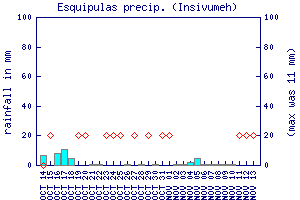
Flow Notes: There is a gauge on the Río Lempa downstream at Citalá, El Salvador. In 2007, 1.3 on the gauge gave 1,000 cfs at the San José bridge. Minimum flows are probably in the 0.8 to 1.0 range. The Equipulas rain gauge can also give a hint as to recent rain patterns.
 |
 |
Nearby Tourist Attractions: Esquipulas cathedral pilgrimage site an hour away.