 rivers | guidebooks | forums | tips | other
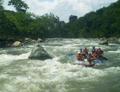
(photo courtesy Maya Expeditions)
Class: IV; Ave. Gradient: 14 m/km; Portages: none; Length: 9 + 16 km; Time: 1.5 + 2 hours
Season: May to November+; rafts? yes; Highlights: continuous whitewater; Crux move: roll
Water Quality: average; Water Temperature: medium
PI: Panán bridge (elev: 290 m); TO: CA-2 (155 m), Finca María del Mar (90 m), or El Arisco (55 m)
Description: (click here for general notes about my descriptions)
The Middle Río Nahualate is one of Guatemala’s signature runs, being the most popular rafting day trip from the capital. It sports continuous bouldery/boogie class IV rapids which get particularly exciting at high water. Kayakers will find some decent play, too, but mostly it’s a fun, rock-or-hole-dodging session. The Lower section of the Río Nahualate is rarely run but offers a way to extend the great Middle section.
A full description is in the Mayan Whitewater Guatemala guidebook.
Descent History: 1st descent in 1996 by Area Verde Expeditions with Dave Bonomo, Mark Haug and Tommy Meng. Has been run at a wide range of water levels.
Flow Notes: There is a gauge on the Río Cutzán, the Río Nahualate's largest tributary which enters in the Middle section. It is a helpful but imperfect predictor of the Nahualate level. The Nahualate has reliable rafting flows June/July and September/October. Good kayak flows happen mid-May to November but those willing to abuse their boats can float pretty much year-round. In general my boat and I prefer higher flows on this run.
 |
Nearby Tourist Attractions: Quiet beaches at El Tulate and Semillero; Los Tarales and Los Andes nature reserves.
mayanwhitewater.com, the guide to the rivers of Chiapas, Guatemala, Belize, Honduras, El Salvador, and Nicaragua © 2008-2026
![]()