 rivers | guidebooks | forums | tips | other
Class: IV+; Ave. Gradient: 11 m/km; Portages: a couple, in upper parts; Length: up to 50 km; Time: up to 9:00
Season: June to February; rafts? yes; Highlights: long IV run; Crux move: getting there
Water Quality: ok; Water Temperature: medium
PI: San Luis (610 m) or Puente Finca San Rafael (440 m) or Puente Pancoc (355 m) or Cooperativa Sacsamani bridge (465 m); TO: La Tinta (Río Polochic)
Description: (click here for general notes about my descriptions)
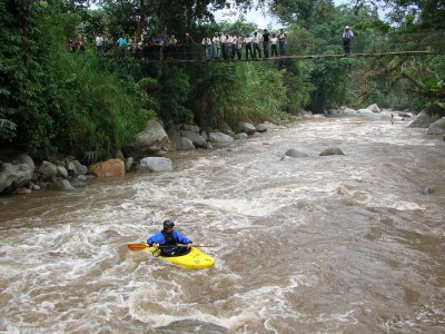
The Río Panimá-Matanzas offers some of the best class III/IV rapids in the country, in one of the prettiest and most remote valleys in the country. This remoteness, coupled with the poor roads, keeps the crowds away, but those that make their way in will be hugely rewarded. In the same area you have the Río Ribacó run to check out also.
A full description is in the Mayan Whitewater Guatemala guidebook.
Descent History: 1st descent was by the Area Verde guys in the 90's, and only a few times since then.
Flow Notes: There is an online gauge near the end of the run. The Matanzas usually has enough water kayaks to get down it throughout the extended Caribbean rainy season, rafters may find it a bit bony during drier spells. My impressions are from an early February run with the Matanzas gauge down to 0.22. The graphs on the right are a compilation of historical data from the past few years, the weekly averages being the solid bars. I believe the more water the better for this run, though it could be quite a workout at higher flows (above 1.0). The Upper, and Ribacó, have more marginal flows, especially after October.
|
|
Nearby Tourist Attractions: The scenery of the Polochic-Matanzas mountains is worth the trip in itself.