 rivers | guidebooks | forums | tips | other
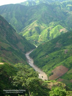
(photo courtesy of Alejandro Villegas Salinas)
Class: III+ / V; Ave. Gradient: 8 m/km; Portages: usually several; Length: 11 & 16 & 9 km; Time: 2 & 5 & 1 hours
Season: May to February; rafts? upper part; Highlights: scenery, challenging rapids in canyon; Crux move: class V canyon
Water Quality: poor; Water Temperature: warm
PI: Jupilingo bridge (upper run, elev: 490m) or Jocotán bridge (lower run, elev: 408m) or San José confluence (lower run, elev: 274m); TO: Jocotán, or Agua Blanca dam
Description: (click here for general notes about my descriptions)
The Río Grande changes names along the way as it passes larger towns; by the end it is known as the Río Grande de zacapa. Above, the Jocotán Canyon section presents some fun challenges and “goes” at low water too, while above that, the Camotán section is mostly easier and shallower. The water comes from a scenic hill area of the Guatemalan-Honduras border with pine trees rooted in colorful soils which makes the river run brown during the rainy season, or even red if certain creeks are up.
A full description is in the Mayan Whitewater Guatemala guidebook.
Descent History: The upper part was first run by a Maya Expeditions crew in 1987. I (Greg Schwendinger) made it through the upper and lower parts in July 2003.
Flow Notes: There is an online gauge at Camotán (data not correlated) which is very useful when it is working. Otherwise there are online gauges downstream on the Río Motagua at Gualán and Morales. The Río Zacapa has a longer season than average, with good kayak flows june through November and reduced ones before and after. Historical data from that gauge are also shown. My impressions are from three canyon descents where I have seen 1,000 cfs, 1,600 cfs, and 250 cfs at Jocotán. Above Jocotán, the riverbed is wider and is not too fun at lower flows.
 |
 |
Nearby Tourist Attractions: Copán Mayan ruins across the Honduran border; Esquipulas cathedral pilgrimage site an hour away.
mayanwhitewater.com, the guide to the rivers of Chiapas, Guatemala, Belize, Honduras, El Salvador, and Nicaragua © 2008-2026
![]()