 rivers | guidebooks | forums | tips | other
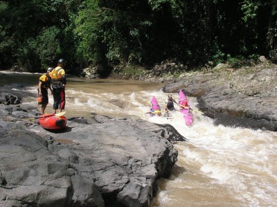
Class: IV; Ave. Gradient: 8 m/km; Portages: sometimes; Length: 22 to 28km; Time: 4-6 hours
Season: June to October; rafts? yes; Highlights: Canyon of the Lost Souls; Crux move: Camila and Ratón Loco rapids
Water Quality: poor; Water Temperature: cool
PI: Nueva Santa Rosa (elev: 934m); TO: above dam reservoir
Description: (click here for general notes about my descriptions)
The Río Esclavos (“Slaves River”) is one of Guatemala’s classic runs and a favorite of us locals, for its scenery, its moderate dose of challenging rapids, and its proximity to the capital. The big rapids are rocky and technical, and can get juicy at high water. Up to six rapids are commonly scouted, with a few of them sometimes portaged. Raft portages are most common at low flows when there are more rocks than water.
A full description is in the Mayan Whitewater Guatemala guidebook.
Descent History: 1st descent by Paul Heesaker, Max Young, Roberto Rodas, and Manolo Rodas, in a raft, in 1995. This was an exciting discovery for them as they deemed it the "world class trip" that Paul's fledgling business, Area Verde Expeditions, needed. It has been kayaked and rafted many times since, sometimes commercially.
Flow Notes: There is a convenient online gauge about 20 km below the TO (and below the dam which spills during the rainy season) and the Esclavos dam inflow estimate at the TO (graphs below). The Esclavos has one of the biggest drainage areas of the Pacific coast rivers, though the region sees less rain than in the west. The run has fairly reliable water in the rainy season, though during drier spells it can be a bit bony for rafts. You will want to see some water flowing over the dam (the one you can see from the El Salvador highway). At low water (< 600 cfs), the PI will have less than 50% of the TO. At high water, it will be over 50%.
|
|
Nearby Tourist Attractions: There are some small lakes in the area mostly popular with locals. The exact geographical center between North America and South America is found in the nearby town of Cuilapa on the El Salvador highway. A monument in the center of town marks the spot.
mayanwhitewater.com, the guide to the rivers of Chiapas, Guatemala, Belize, Honduras, El Salvador, and Nicaragua © 2008-2026
![]()

