 rivers | guidebooks | forums | tips | other
Class: IV-; Ave. Gradient: 10 m/km; Portages: none; Length: 13 km; Time: 1.5 to 3 hours
Season: June to November; rafts? yes; Highlights: nice jungle; Crux move: 1st rapid
Water Quality: poor; Water Temperature: medium
PI: Sinacantán bridge (245 m) or CA-2 bridge (124 m); TO: Parcelamiento Bebedero
Description: (click here for general notes about my descriptions)
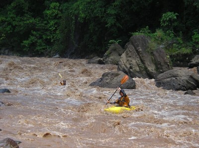
The Lower Río Esclavos still has a little punch left and a nice jungly canyon to enjoy. It is a fun juicy ride when the water is high, and also makes a nice easier option when the water is low.
A full description is in the Mayan Whitewater Guatemala guidebook.
Flash Flood Danger: low, the canyon is not too narrow.
Descent History: 1st descent by Paul Heesaker, Max Young, Roberto Rodas, and Manolo Rodas, in a raft, in 1995.
Flow Notes: The Lower Río Esclavos has a kayakable flow all rainy season long, and for a few weeks after. In dry spells it can get shallow, especially for rafts. The gauge upstream will help guide you: in 2020, 2200 cfs on the gauge translated to over 4,000 cfs in the Lower.
Note that there is a hydroelectric dam between the upper and middle sections but it has only minimal impact on boating. The reservoir is shallow from silt build-up so the dam is always spilling in the rainy season or anytime the power is off for more than a day. The actual releases through the turbines are only 50 to 100 cfs, so are a negligible component in the rainy season and do little to help boaters in the dry season.
|
Nearby Tourist Attractions: beach at Monterrico.