 rivers | guidebooks | forums | tips | other
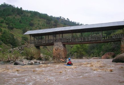
Class: III+; Ave. Gradient: 14 m/km; Portages: none; Length: 27 km; Time: up to 8 hours
Season: June to October; rafts? bottom bits; Highlights: high altitude with class III attitude; Crux move: catching the water
Water Quality: poor; Water Temperature: cool
PI: Chixal bridge (2150 m); TO: Sipacapa bridge (1670 m) or Siete Platos bridge (1612 m)
Description: (click here for general notes about my descriptions)
The Río Cuilco gives paddlers the longest stretch of feasible whitewater in Central America, over 130 km in Guatemala alone, plus another 33+ km in Mexico (before it hits its first dam and becomes the Río Grijalva). It is set in particularly rugged terrain with dramatic canyons the entire length. Practically all of it is class III/III+ and with no mandatory portages. It all starts on the Upper at Central America’s highest PI, on the flanks of Central America’s highest peak, the Tajumulco volcano.
A full description is in the Mayan Whitewater Guatemala guidebook.
Descent History: I ran the Upper with Gary Lee Chrisman in October 2004. Axel Álburez, a Guatemalan, paddled solo down to the Siete Platos bridge around 2009.
Flow Notes: The only online gauge is way downstream in Mexico. (This is the San Miguel
gauge on the Río Independencia. I have not correlated flows to this gauge, but I think you
would want to see 20,000 cfs or more on that gauge to have a shot of running the Upper Río
Cuilco.) you will want to see regular rain on the Huehuetenango and Quetzaltenango rain
gauges. Before driving up to the PI I would suggest either driving down to the TO, where
you would like to see a minimum of 1,000 cfs, or running the Lower Río Cuilco first.
 |
 |
Nearby Tourist Attractions: Tajumulco volcano.
mayanwhitewater.com, the guide to the rivers of Chiapas, Guatemala, Belize, Honduras, El Salvador, and Nicaragua © 2008-2026
![]()