 rivers | guidebooks | forums | tips | other
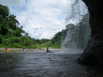
Class: III+; Ave. Gradient: 7 m/km; Portages: none; Length: 7-24 km; Time: 1:30-6:00
Season: May to December+; rafts? yes; Highlights: scenery; Crux move: finding the driver at the TO
Water Quality: poor; Water Temperature: warm
PI: Naranjo (elev: 245m); TO: Coyolate or Cruce de Don Genaro (or other finca access in between)
Description: (click here for general notes about my descriptions)
The Río Coyolate is a perennial favorite of intermediate kayakers and rafters. It has nice jungle scenery, a remote feel, and enough rapids and play waves to keep things interesting. Plus, it is relatively close to Antigua and the capital.
A full description is in the Mayan Whitewater Guatemala guidebook.
Flash Flood Danger: low.
Descent History: First descent by Area Verde guys in 1996. (Area Verde was a company doing rafting/kayaking tours in Guatemala for a few years in the 90's, founded by Paul Heesaker from Colorado with subsequent partners Josh Anthony and Roberto Rodas.) The Coyolate sees a couple descents a year, and has been run at widely varying water levels.
Flow Notes: There is a gauge near the PI. The more water the better on the Coyolate (though at 2500+ cfs the river should be considered a class IV), unfortunately the level drops rather quickly during dry spells. Rafters are often left wanting more water; their best bets are June to October. But there is always some water in the river, and desperate kayakers willling to abuse their boats can still put-on the first few months of the dry season, or in some years after early rains in April and May.
 |
Nearby Tourist Attractions: Atitlán lake and Sipicate beach
mayanwhitewater.com, the guide to the rivers of Chiapas, Guatemala, Belize, Honduras, El Salvador, and Nicaragua © 2008-2026
![]()