 rivers | guidebooks | forums | tips | other
.jpg)
Class: III+/IV-; Ave. Gradient: 3 m/km; Portages: none; Length: up to 19.5 km; Time: 3-4 hours
Season: June to December; rafts? no; Highlights: wildlife; Crux move: taking out at the dam
Water Quality: poor; Water Temperature: cool
PI: bridge east of Cobán (1302 m) or San Pedro Carchá (1275 m); TO: Renace I dam (1250 m)
Description: (click here for general notes about my descriptions)
Before the Río Cahabón falls down the mountain and becomes a tourist and rafting attraction 40 km downstream, it is the largest creek in the Cobán area. Though it is polluted by the big towns, the color of the water is an enchanting emerald green, and I found the part around San Pedro Carchá (SPC) a worthwhile diversion for the scenery, the wildlife, and a few nice rapids.
A full description is in the Mayan Whitewater Guatemala guidebook.
Descent History: I ran this solo in July 2009, with 200 cfs at the PI.
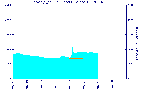
Flow Notes: There should usually be a boatable flow here July to November and possibly before and after. The Renace I dam on the Río Cahabón downstream reports an inflow estimate which is helpful. The Cobán rain gauge is also helpful. Higher flows than I had are commonly seen here and might create a few more class IV rapids.
 |
 |
Nearby Tourist Attractions: coffee and tea farms.