 rivers | guidebooks | forums | tips | other
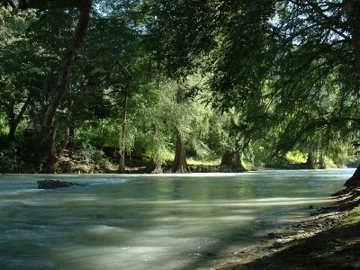
Class: IV, II+; Ave. Gradient: 16, 6 m/km; Portages: maybe in Upper; Length: 15, 15 km; Time: up to 3, 2 hours
Season: June to November; rafts? no; Highlights: beautiful colors and trees; Crux move: limbo in the Lower
Water Quality: decent; Water Temperature: not noted
PI: Xayomlaj (930 m), Yinchengüex (795 m), Pebilpam (695m), or La Laguna bridge (670 m); TO: Dolores bridge in Mexico (607 m)
Description: (click here for general notes about my descriptions)
The Río Azul (“blue river”) is a special place, with milky blue-green water flowing under a idyllic tree canopy, many of which are splendid sabino trees that favor the shoreline. (The sabino, a.k.a. Montezuma baldcypress, is the national tree of Mexico, and in Guatemala is only found in the department of Huehuetenango.) Above the riparian zone is mostly coffee groves. The Río Azul is often lacking for water, but worth doing if not excessively low.
A full description is in the Mayan Whitewater Guatemala guidebook.
Descent History: I first ran the Upper starting at Inchegüex in November 2003, with 200 cfs at the PI, from Xayomlaj with Victor Maza in August 2024 with 400 cfs, and the Lower in June 2009, with 300 cfs.
Flow Notes: There is an online gauge at the highway bridge!
 |
Nearby Tourist Attractions: the Cimarron sinkhole north of Nentón.
mayanwhitewater.com, the guide to the rivers of Chiapas, Guatemala, Belize, Honduras, El Salvador, and Nicaragua © 2008-2026
![]()