 rivers | guidebooks | forums | tips | other
Join a SierraRios trip on the Usumacinta! click here

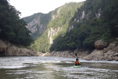
(photo courtesy of German Arroyo)
Class: III; Ave. Gradient: < 1 m/km; Portages: none; Length: up to 144 km; Time: 3-6 days
Season: year-round; rafts? yes; Highlights: ruins, nature, multi-day; Crux Move: the San José whirlpools
Water Quality: so-so; Water Temperature: warm
PI: Frontera Echeverría Corozal or higher (elev.: 93 m); TO: Boca del Cerro
Description: (click here for general notes about my descriptions)
The Usumacinta is a classic adventure and cultural tour traversing the heart of the ancient Mayan kingdoms. It is MayanWhiteWater-land's (and Mexico's) most volumnous river, and measuring from the headwaters in Guatemala, the longest. The lower section passes by the major ruins of Yaxchilán and Piedras Negras on its way through some impressive limestone gorges and large expanses of rainforest teeming with birds, monkeys, and other wildlife. It gained a reputation for being dangerous in the 80's and 90's when several raft expeditions were mugged by banditos but a criminal group was caught by the Guatemalan army in 1999 and the river is mostly crime-free since then (though the area is a corridor for drugs and tourists should attempt to acertain the current situation). Also in its recent history is a heated debate over government plans for multiple dams along its length (part of the Mesoamerican Project, formally the Plan Puebla Panamá) which currently are on the back burner.
A full description is in the Mayan Whitewater: Chiapas & Belize guidebook.
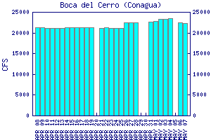
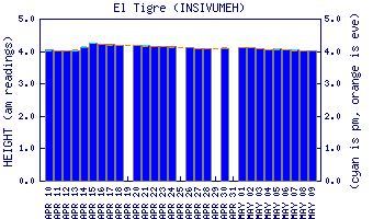
Flow Notes: There is a useful gauge at the TO, linked to below. Robey recommends running the river during low water (January to May), and since I have no specific reports from high-water runs, you should regard the previous description as applicable to relatively low flows. I also have historical data from INEGI (El Tigre is upstream of the PI):

click here for the height graph |
 |
Nearby Tourist Attractions: more Mayan ruins at Palenque and Bonampak.