 rivers | guidebooks | forums | tips | other
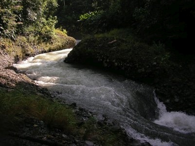
Class: IV-; Ave. Gradient: 12 m/km; Portages: could be; Length: 30 km; Time: 6:00
Season: June to October; rafts? lower bits; Highlights: gorgeous jungle scenery; Crux move: twisting mini-gorge
Water Quality: decent; Water Temperature: not noted
PI: Chapultepec bridge (elev: 480 m); TO: Río Huehuetán bridge on coastal highway
Description: (click here for general notes about my descriptions)
The Río Mejapa is a narrow volcanic gutter in an especially verdant fold of the coastal mountains, and a micro-creeker's delight. With it's lush jungle scenery and squawking parrots everywhere, it's a true tropical garden, and with over 1000 feet of elevation drop, kayakers get to experience its fun as well as its beauty.
A full description is in the Mayan Whitewater: Chiapas & Belize guidebook.
Flow Notes: It is not easy to catch a boatable flow at the upper PI. There is an online gauge just downstream of the confluence with the Huehuetán (linked below) though it's been out of commission for a few years now. Other coastal gauges can give you an idea of trends, as can the Finca Argovia (Upper Huehuetán) rain gauge. Scouting at the TO bridge will give you the quickest measure but not much indication of what you'll have at the PI. Another guide is you'll want to see at least 1000 cfs in the larger rivers in the area (Cahoa, Coatán, Huehuetán) to make it worth the drive upstream. My impressions are from a low water run, with ~100/2000cfs at the PI/TO. Historical data from INEGI (from the gauge point) is included below.
 |
 |
 |
 |
Accommodations: Tapachula makes a convenient base for this run.
Nearby Tourist Attractions: Proto-Mayan ruins at Izapa; Tacaná volcano; Puerto Madero beach.
mayanwhitewater.com, the guide to the rivers of Chiapas, Guatemala, Belize, Honduras, El Salvador, and Nicaragua © 2008-2026
![]()