 rivers | guidebooks | forums | tips | other
Class: III; Ave. Gradient: 6 m/km; Portages: maybe one; Length: 13 km; Time: 2.5 hours
Season: mid-June to mid-December; rafts? no; Highlights: nice option for beginners; Crux Move: getting permission
Water Quality: decent; Water Temperature: cool
PI: Petultón bridge (913m); TO: Balneario Jataté
Description: (click here for general notes about my descriptions)
The Far Upper Jataté is nothing like its famous, lower section, cousins. It's a gentle stream flowing through a wide valley not too far from civilization.
A full description is in the Mayan Whitewater: Chiapas & Belize guidebook.
*note* This run is marked politically sensitive due to villagers near the PI being suspicious of outsiders. On our run we failed to ask "permission" from the folks in Petultón and we were chased down the river by a group of them and forced to stop (they actually threatened to stone us if we didn't). After explaining that we were just tourists they were satisfied and let us continue. I suggest you allow some time for a little chat with village leaders in Petultón before you put-on
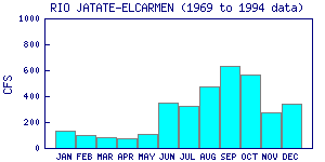
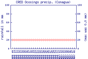
Flow Notes: There are no gauges close enough to be of relevance. You will need the luck of recent and regular heavy rains to find enough water. I suggest checking the flow at the TO ahead of time. We had about 200 cfs on our descent. Here I show historical data from INEGI, from a gauge well above the PI (I don't believe the flow numbers though), as well as the nearby Ocosingo rain gauge.
 |
 |
Accommodations: There are many hotel choices in Ocosingo.
Nearby Tourist Attractions: Toniná Mayan ruins