 rivers | guidebooks | forums | tips | other
Class: IV- upper, III middle; Ave. Gradient: 11 m/km upper, 6 m/km middle; Portages: maybe 1 in upper; Length: 10 km upper, 11 km middle; Time: 3:30 upper, 1:30 middle
Season: August to October; rafts? no; Highlights: pretty gorge in upper section; Crux move: class V part of pretty gorge
Water Quality: good; Water Temperature: medium
PI: upper: Salvador Urbina (elev: 800 m), middle: hammock bridge above Querétaro (elev: 690 m); TO: middle: Angel Albino Corzo
Description: (click here for general notes about my descriptions)
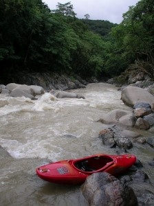
The Río Jaltenango is in the way-off-the-beaten-path area of the middle Grijalva valley. The area is mainly of interest to explorers who are around during the height of the rainy season and who are looking for something rarely-visited. Here, they'll find it.
A full description is in the Mayan Whitewater: Chiapas & Belize guidebook.
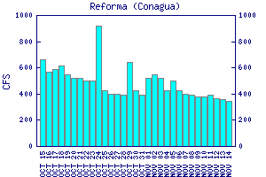
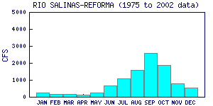
Flow Notes: There is a convenient streamflow station in at the highway, and not far downstream at La Reforma, both on my maps. The latest charts are also shown below. Both gauges appear to read high: in 2012, readings of 4500 & 4000 cfs gave real flows of 1500 & 3000 cfs. I would want at least 500 cfs at Jaltenango (1500 cfs on the gauge?) to make the drive out here. My impressions are from a run with about 350/550 cfs at the PI/TO. Also here I include some historical data from INEGI.

click here for the height graph |

click here for the height graph |
 |
Accommodations: There are basic hotels in Ángel Albino Corzo town.
Nearby Tourist Attractions: This area is far off the gringo trail. Nature buffs will appreciate the unspoiled "Reserva de la Biosfera El Triunfo" which borders the lower Río Jaltenango though it has no tourist services.