 rivers | guidebooks | forums | tips | other
Class: III; Ave. Gradient: 7 m/km; Portages: none; Length: up to 33km; Time: up to 5 hours
Season: mid-June to October; rafts? yes; Highlights: big-water rafting; Crux Move: picking your TO
Water Quality: poor; Water Temperature:warm
PI: Puente Amatenango (elev.: 850m); TO: Frontera Comalapa (or above)
Description: (click here for general notes about my descriptions)
The Río Cuilco, aka the upper Grijalva, is the final free-flowing stretch of whitewater before it enters a series of dams and reservoirs on the lower Grijalva, Chiapas' mammoth engineering project. (A whole lot more whitewater lies upstream in Guatemala, described here.) The river was the scene of massive flooding in 2005 during Hurricane Stan, and left a wide bare riverbed that is now starting to grow back in.
A full description is in the Mayan Whitewater: Chiapas & Belize guidebook.
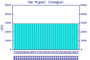
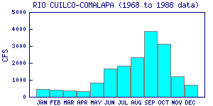
Flow Notes: There is an online gauge downstream at San Miguel (below the confluence with the Río Independencia), linked to below. My impressions are with 2500 cfs. Here I also show historical data near the TO from INEGI:

click here for the height graph |
 |
Accommodations: Frontera Comalapa has several budget hotel options.
Nearby Tourist Attractions: There are not so many in this area.