 rivers | guidebooks | forums | tips | other
Class: V-; Ave. Gradient: 16 m/km; Portages: maybe; Length: 14 km; Time: 4:00
Season: July to December; rafts? yes, lower; Highlights: nice slides; Crux move: careful scouting
Water Quality: ok; Water Temperature: medium
PI: Chavajebol bridge (elev: 515m); TO: Mazantic bridge
Description: (click here for general notes about my descriptions)
*This run is marked politically sensitive due to general suspicion of outsiders in the area. In 2015 a group of kayakers was stopped just below the class V sequence and questioned at length, and were told that tourists were not welcome in that area. You should check with the mayor’s office in El Bosque about the situation before putting on.*
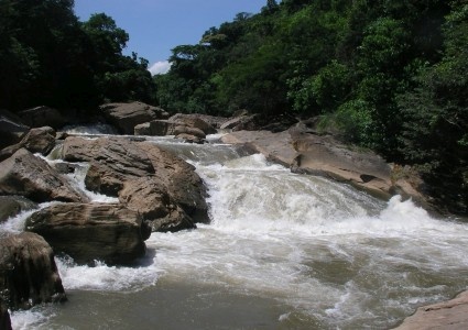
The Río Chabajebal is one of the best runs in the fabulously scenic and whitewater-rich northern ranges of Chiapas. The views from the top of the valley down to the river are simply breathtaking, and the quality rapids do not disappoint.
A full description is in the Mayan Whitewater: Chiapas & Belize guidebook.
Flow Notes: The only online gauges are downstream on the Río Almandro (fairly accurate in 2009). The Mazantic contributes about 20% of the Oxolotán/Tapijulapa totals. The drainage is quite large, so if other streams in the area (e.g., La Sierra) have water, the Mazantic should have more. I believe you have a very good chance to find a runnable flow August to October. My impressions are from a run with 700 cfs at the PI.

| 
|
Nearby Tourist Attractions: This area does not see many tourists. All the roads in the area are very scenic. Tuxtla Gutierrez and San Cristobal de las Casas are about 3 hours away.