 rivers | guidebooks | forums | tips | other
Class: IV+ (V); Ave. Gradient: 6 m/km; Portages: a couple; Length: 29 km lower; Time: 7:00
Season: June to February; rafts? portages; Highlights: beautiful canyons; Crux move: Itzantún canyon
Water Quality: fair; Water Temperature: warm
PI: Puente Santa Catarina near Huitiupán (elev.: 233m); TO: Oxolotán
Description: (click here for general notes about my descriptions)
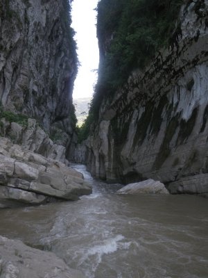
The lower Almandro is a spectacular run with unique river features and the biggest non-travertine class IV whitewater in Chiapas. It starts off with a tricky slot-canyon passage, later calms down through some scenic stretches, then leads to a final canyon with a good number of challenging rapids. The section is long enough and easily combined with others both upstream and downstream that this makes a great overnight trip (or even 3 days).
A full description is in the Mayan Whitewater: Chiapas & Belize guidebook.
Descent History: The first descent of the Lower Almandro was by Jeff Hastings and Greg in September 2009. A few other groups have run it subsequently.
Flow Notes: There is a convenient online gauge at Oxolotán. The gauge was fairly accurate in 2009, though currently (2015) only (uncalibrated) height is shown. Higher water is found September to November. We had about 1500 cfs (fun) at the PI on our run, with other known runs seeing up to 50% more. The river is runnable at a wide range of water levels, though, again, the critical point to consider is Itzantún

|
 |
Accommodations: There are basic hotels in Huitiupán near the PI.
Nearby Tourist Attractions: near Oxolotán: Cuevas Kolem Chen, various other caves, and the Kolem Jaa ecotourist resort.