 rivers | guidebooks | forums | tips | other
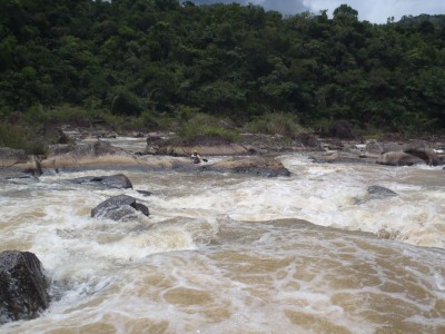
Class: IV (V); Ave. Gradient: 5 m/km; Portages: 0-3; Length: 16 km; Time: 4 hours.
Season: July to February; rafts? no; Highlights: bedrock rapids and Maya Mountains scenery; Crux moves: getting access and avoiding the crocodiles.
Water Quality: decent; Water Temperature: warm.
PI: Guacamayo bridge (elev: 355m) or Chalillo dam; TO: Mollejón dam
Description: (click here for general notes about my descriptions)
A full description is in the Mayan Whitewater: Chiapas & Belize guidebook.
mayanwhitewater.com, the guide to the rivers of Chiapas, Guatemala, Belize, Honduras, El Salvador, and Nicaragua © 2008-2026
![]()